For flooding inquires, flood reporting, and drainage issues please email the NJSEA at flood@njsea.com.
The National Flood Insurance Program (NFIP), which is administered by the Federal Emergency Management Agency (FEMA), offers reasonably priced flood insurance in communities that comply with minimum standards for floodplain management. The NFIP’s Community Rating System (CRS) was implemented in 1990 as a voluntary program for recognizing and encouraging community floodplain management activities exceeding the minimum standards by reducing flood insurance premiums for the community’s property owners.
Through NJSEA participation in the voluntary CRS program since 1992, property owners, businesses and tenants located in Special Flood Hazard Areas within the Meadowlands District have been eligible for a 15 percent discount on flood insurance policies issued by the NFIP. This discount is applicable when property owners purchase or renew their policies. In order to maintain the discount, the NJSEA is required to administer, and to verify annually with the NFIP, activities in the District, which include, but are not limited to, flood data maintenance (Elevation Certificates), open space preservation, community outreach projects, map information services, upholding stormwater management standards and drainage system maintenance.
In accordance with CRS requirements, the agency initially drafted the Hackensack Meadowlands Floodplain Management Plan as a guide to assess and identify flood hazards in the District. The plan, developed in cooperation with Meadowlands District municipalities, and other stakeholders, prioritizes floodplain management initiatives and proposes mitigation strategies. The Floodplain Management Plan is being updated in compliance with the 2022 CRS audit.
Hackensack Meadowlands District Floodplain Management Plan 2022
2019 Floodplain Management Regulations
INTERACTIVE MUNICIPAL FLOOD PREDICTION MAPS AND ALERTS
Through the Meadowlands Research & Restoration Institute the NJSEA offers a water alert system and flood maps to first responders and the public. The email and text-based alerts for municipalities in the Meadowlands District are issued when water levels reach 5.5 feet above sea level and continue to be relayed as the levels rise. The interactive, web-based flood prediction maps illustrate the portions of the Meadowlands District which may flood at sea surge levels ranging from 4 to 8 feet above sea level.
Flood Prediction Maps and Sign up for Alerts
ADDITIONAL NJSEA DRAINAGE PROJECTS
The NJSEA annually inspects tide gates and pump stations and major drainage ditch systems in the Hackensack Meadowlands District. Eight of the tide gates are monitored on a continuous basis. Real time access to the tide gate data can be found at https://meri.njmeadowlands.gov/ and then clicking on the “Environmental Monitoring Data” link from the “Scientific Data” pulldown menu.
In 2014, the construction was completed for the replacement West Riser Tide Gate, which is located along Berry’s Creek near the Teterboro Airport. This tide gate helps to protect Teterboro Airport and properties in Moonachie and Carlstadt upstream of the tide gate from daily tidal flooding.
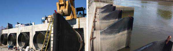
The NJSEA also completed the Route 17 Floodplain Management Project in Rutherford and East Rutherford in 2010. This project, which involved the installation of 11 new tide gates and culverts as well as restoration of the drainage ditches, has greatly reduced the amount of storm surge waters that reach the highway during tidal events.
New tide gates installed at the Moonachie and Bashes Creeks in Carlstadt during 2010 also stem storm surge related flooding in the Carlstadt industrial area located east of Washington Avenue.
Other past projects include the restoration of several drainage systems in Carlstadt and Moonachie, the installation of a new tide gate at Palmer Terrace in Carlstadt, and the installation of a new trash rack on the East Riser Tide Gate in Moonachie to improve efficiency.
In order to maintain natural buffer areas between the Hackensack River and the developed areas, the NJSEA continues to acquire critical tracts of wetlands. To date the agency has acquired 2,500 acres of wetlands to help dissipate storm events and tidal flows.
OTHER HELPFUL LINKS
FEDERAL EMERGENCY MANAGEMENT AGENCY
Floodsmart: Official Site of the National Flood Insurance Program
General information about the National Flood Insurance Program
UNITED STATE ARMY CORPS OF ENGINEERS
STATE/COUNTY
New Jersey Office of Emergency Management
U.S. Geological Survey – New Jersey District
Bergen County Office of Emergency Management
Hudson County Office of Emergency Management
NJDCA – Flooding Hazards: What you need to know
DRAINAGE REGULATIONS
Meadowlands District
Stream Dumping